File:DoomsdayMap.png
From The Three Kingdoms
Jump to navigation
Jump to search

Size of this preview: 800 × 407 pixels. Other resolutions: 320 × 163 pixels | 1,308 × 665 pixels.
Original file (1,308 × 665 pixels, file size: 234 KB, MIME type: image/png)

|
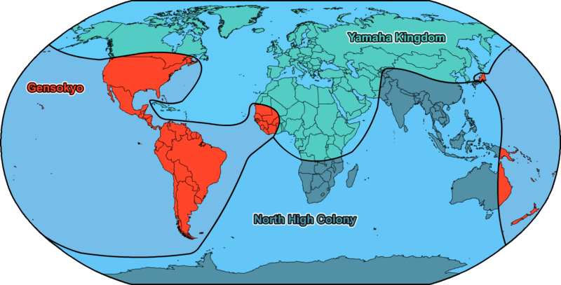
This image is on deviantART, where more information can be found on its image page. This is a map of territorial control by the end of Doomsday, 21st December 2012, of the [[Yamaha Kingdom (The Three Kingdoms)|Template:Biography Yamaha Kingdom (The Three Kingdoms)]], [[Gensokyo (The Three Kingdoms)|Template:Biography Gensokyo (The Three Kingdoms)]] and the [[North High Colony (The Three Kingdoms)|Template:Biography North High Colony (The Three Kingdoms)]]. See also: Equivalent Chapter Artwork and Next Territorial Control
dra2k4, the creator of this image, has given permission to The Three Kingdoms Wiki to use the image across the site. This does not affect rights of other websites and this image continues to fall under the copyright terms stated in the Terms of Service and any conditions stated on image's page on deviantART. In short, the use of this image on this wiki does NOT allow this image to be used elsewhere without the creator's permission. |
File history
Click on a date/time to view the file as it appeared at that time.
| Date/Time | Thumbnail | Dimensions | User | Comment | |
|---|---|---|---|---|---|
| current | 10:21, 27 September 2014 |  | 1,308 × 665 (234 KB) | Dra2k4 (talk | contribs) | {{ImageCreditbox |subject= |subjecttext=Map of territorial control by the end of '''{{a|The Three Kingdoms|Doomsday}}''', 21st December 2012, of the {{a|The Three Kingdoms|Yamaha Kingdom}}, {{a|The Three Kingdoms|Gensokyo}} and the {{a|The Three Kingdo... |
You cannot overwrite this file.
File usage
The following 3 pages use this file:


